


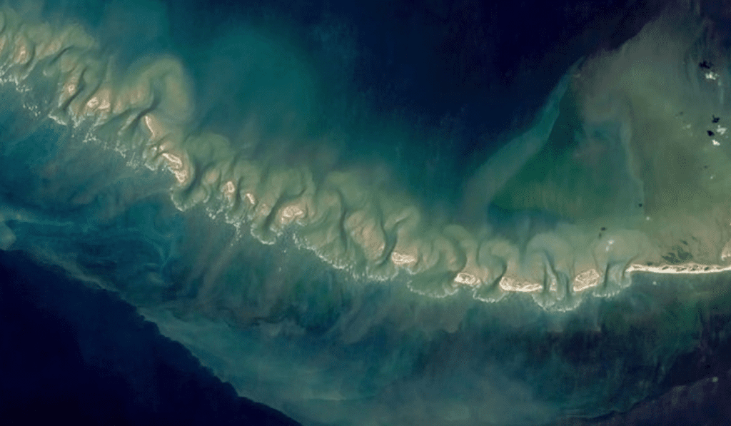
In a pioneering joint effort, ISRO and NASA have mapped the Ram Setu, also known as Adam’s Bridge. This historic submerged structure extends between Mannar Island in Sri Lanka and Rameswaram Island in India. The project employs cutting-edge laser technology to offer new and detailed insights into this mysterious underwater region.
NASA’s ICESat-2 Satellite Delivers High-Resolution Imagery of Ram Setu
Utilising NASA’s ICESat-2 satellite, the project achieved high-resolution imagery of Ram Setu, capturing details up to 40 meters beneath the sea level. The ICESat-2’s sophisticated green laser technology was crucial, penetrating the deep waters and mapping the seabed with extraordinary precision, gathering about 0.2 million photons to create a detailed bathymetric map at a 10-meter resolution.
Also Read: India’s Tiranga: A Symbol of Unity and Pride
Reveals 11 New Submerged Channels
The comprehensive mapping process revealed that Ram Setu spans 29 meters in length and stands 8 meters above the seabed, stretching across a width of 1.5 kilometers. This detailed survey also unveiled 11 previously unknown submerged channels, adding depth to our understanding of the bridge’s complex underwater structure.
Bridging Mythology and Science in the Exploration of Lord Ram’s Legendary Construct
Setu holds profound historical and cultural significance in Indian mythology, believed to be constructed by Lord Ram, as depicted in the epic Ramayana. This connection provides a unique intersection of myth and science, as the bridge’s physical remnants are explored in tandem with its legendary narratives.
Also Read: 10 Useful Things You Can Learn in Less Than 10 Minutes
Scientific Analysis Reveals Ram Setu’s Historical Land Connection and Submersion Timeline
Scientific analysis suggests that Ram Setu was once a land connection between India and Sri Lanka, only to be submerged following a severe storm in 1480. The project’s findings on the geological shifts and the historical timeline of the structure offer vital clues to the bridge’s past and its dramatic transformation over the centuries.
Impact of ISRO-NASA Collaboration on Marine Geophysics and Archaeology
The valuable data from this mapping effort sets the stage for deeper research in marine geophysics and archaeology. It enhances our comprehension of submerged structures, providing new opportunities to explore ancient civilizations and evaluate the effects of climatic events on geological formations.
The joint effort between ISRO and NASA not only reveals the submerged mysteries of Ram Setu but also demonstrates the power of modern technology in historical and geological studies. This project enriches our historical insights and emphasizes the significance of international scientific collaboration in uncovering the ocean’s hidden secrets.


More Stories
Two Lok Sabha MPs Refuse Salary: Meet the Lawmakers Who Decline Pay
IT कंपनियों पर बढ़ सकते हैं साइबर हमले NASSCOM ने सुरक्षा बढ़ाने की दी सलाह
US-Iran conflict impact: Market turmoil and protests in Parliament